Tuesday, November 11, 2008

Pfossental

17.09.2008
This was our last day in South Tirol - we had been changing our plans from a week of hiking on the swedish Kungsleden trail to day trips around the Merano area. We have not given up on the plans for Kungsleden, but we found those tours in italy a very nice alternative! 
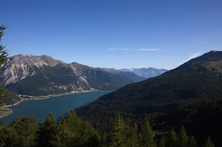
The last trip led us back on to the Meeraner Höhenweg No 24 (the northern part)
We started from a parking lot in the Pfossental and went towards the "Eisbergspitze".
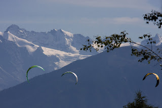
It was like this area wanted us to come back and make sure we have been not disappointed with the change in travel plans. I highly recommend this part - just look at the pics.


Ilfinger area - E5 to Kratzbergsee

16.09.2008
We used the Ilfinger Gondola and started another beautiful hike on the E5 - a long trail that starts in Germany and went down to italy for many hundred miles. From this side you can do the hike to Kratzbergsee and then continue to the Hirzer summit and down to the Hirzer Huette. Or you return from the lake and do some nice sidetrips before using the Ilfinger gondola again to go back into the valley. The weather had improved and it turned out to be just another very exciting tour. The whole area is of such a beauty! However, the first few kilometres are a little packed with people, but never to a level where it is no fun anymore to hike here.

Kratzbergsee

Flecknerspitze 2350m

15.09.2008
We followed our tour book and wanted to hike to the summit called "Fleckner Spitze". We started from shortly below the "Jaufenpass" at the "Enzian Hütte" (where we had a good soup just before leaving into the cold) The weather was much more uncomfortable then before. 
We had snow and ice and the view was very limited - on the other hand we felt great and proud - even if we looked like Ninja turtles a bit :-) 

There was also no awarding great outlook from the summit - just fog and wind. 
We stayed for a while but then left towards the "Fleckner Huette" - as usual, we had some food and a good glass of wine. 
Note: there is a really big black dog at the Fleckner Huette. He might run to you and if you are a little bit afraid of dogs, that might be frightening to you. Trust me - he only want's to play and is a nice boy!

Vellauer Felsenweg 22

13.09.2008
We took the bus to Vellau and then picked up the gondola and continued with the lift (Korblift) to the top of the Meeraner Höhenweg. A short hike gets you to the "Leiter Alm" - a nice place for a rest but since we just started, we turned to the right and followed this fantastic way. 
You can also turn to the left - you are still on tour 24 - the famous "Meeraner Höhenweg".

Leiter Alm

Vellauer Felsenweg 22

safety in the forrest

We followed the way until the Vellauer Felsenweg splits to the right. (Hochmuth Alm)
This way can be dangerous, especially in winter. (some people lost their lives here) 
So be cautious - we found it just great and not threatening at all. The weather however became bad now and it obviously looked like a lot of rain to come in the near future. We just finished the dangerous part of the way and entered the forrest as a strong thunderstorm hit us. Actually, we had been lucky - you do not want to have such a storm while you still are on the small and steep way down - very much exposed to the wind and rain!

Karer See

12.09. - 16.09.2008
We continued with a number of nice tours over the next days. We started with a tour by car to the famous Karersee and continued to the Sexter Dolomites near Cortina D'Ampezzo. The weather was not that good and we wanted to explore the wider area at least a bit. The Karer See is nice, but you can expect a large number of tourist groups dropped there for a short hike around the lake. It's not worth to go there more than once :-)

Karer See


Saturday, October 11, 2008

Pfandlerspitze

11.09.2008: Today we started a trip at the "Hirzerhuette" at 1983 m. You take the Gondola from Saltaus, north of Merano. 
The whole Hirzer area is just great for various tours - you can hike on the E5 trail and pass the Hirzer summit (2698m) and continue for many more miles on this fantastic trail.
We hiked the trail number 2, which passes the Hintereggalm if you want, but we kept on trail 2 and continued to the Pfandlerspitze. 
Well, what can i say, we had again unbelievable good weather and the whole tour was just a lot of fun. 
You leave the Mahdalm to the left and continue on route 2 to the Pfandlerspitze. The last part is a bit more dangerous - you simply need to watch your steps. Otherwise, it's just a perfect trip.

We returned the same route and enjoyed the wine and local food at the Hirzerhuette at the end of a nice day before we catched the last gondola down to Saltaus.

I do not take any responsibility for outdated, false or incorrect information. You should not expect that all information is 100% correct or fits your needs if you travel your own way on similar trips.

Thursday, October 9, 2008

St. Vigil and Naturnser Alm

10.09.2008 - trip to Naturnser Alm
We started in Oberlana and catched the Gondola up to Vigil Joch. Lana is a little bit south of Merano. Well, there have been MANY people waiting to catch that gondola and , like most of the others, the trip is quite expensive. 
However, the weather was again fantastic and St. Vigil is the first thing you see. A nice little church on top of a hill. 

The trip is easy and you have nice views almost all time until you finally reach the Naturnser Alm. There is not a lot in this world that can top the view and the nice food at this place. If you have the weather we had then your day is made.


I do not take any responsibility for outdated, false or incorrect information. You should not expect that all information is 100% correct or fits your needs if you travel your own way on similar trips.

Monday, September 29, 2008

09.09.2008 Reschen and Reschen Alm
From Stilftser Joch you can easily drive north to the Reschen Pass. The little village is known for the church's clock tower that is the only remaining building from another little village, that had been flooded. 

Have a coffee in the Cafe across the street and then drive around the lake a bit and start the hike to the Reschen Alm. It's a nice and easy hike and at the end you have a great view down on the lake and the clock tower. And well, the food is , as ususal, VERY good at the Alm.

I do not take any responsibility for outdated, false or incorrect information. You should not expect that all information is 100% correct or fits your needs if you travel your own way on similar trips.

Day 1 - Stilftser Joch - 3170m

09-09-2008 Stilftser Joch
We had a perfect day with unbelievable clear weather - a perfect day to drive on one of the most spectacular roads to the famous Stilftser Joch.
From Merano it's about 70km's , but you need to take into account that this road (the last part up to the Joch) is quite special, so drive slowly. (you can see the road on the picture below)


You can use your bike or car (well, make a guess what is harder) and drive up to the Joch at 2760m. Then take the (expensive) Gondola up to 3170m. 

There is a glacier where people can ski all year long but you can clearly see the climate changes already if you look at the glacier.

Down at 2760 m again you have plenty of choice to purchase souvenirs and expensive but special "Bratwurst"
I do not take any responsibility for outdated, false or incorrect information. You should not expect that all information is 100% correct or fits your needs if you travel your own way on similar trips.

Friday, September 26, 2008

2500 km's further south ....


Well, we changed the planned location towards :
Italy, South Tirol - so just a 2500 km further south location. :-)
We quickly searched the Internet for a nice, not too expensive apartment and booked online. We ended up at Siggi's apartment in Partschins, a little village west of Merano, in an area called "Vinschgau".
It's surrounded by mountains, has easy access to hundreds of hiking tours from blue (easy) to black (hard).
The appartment was 80€ per night (high season) , had it's own kitchen and plenty of place for 2 people. (3 would have been fine as well)
Get one of the "Tabacco" topographic maps (number 11 for the Mearno area) and you have plenty of choices for great hiking tours. There are many huts (Alm's) on the trails with great food where you even can stay overnight (make reservation upfront!)

There are many well known long distance trails , e.g. the E5 trail as well as Route 24 (Merano high mountain circle - 5-7 days) but we chose to do nice day hike's.
The weather was great and we had views like this one below: so we quickly felt like we did the right thing with changing plans. (Hey, we still like Sweden and plan to do the Kungsleden)


Note: I do not take any responsibility for outdated, false or incorrect information. You should not expect that all information is 100% correct or fits your needs if you travel your own way on similar trips.

Thursday, September 25, 2008

A last minute travel plan change - Kungsleden has to wait

Hi, my name is Rainer

Well, this is my first entry about the different trips i made and still plan to make in the future. And it starts with a last minute change ...
I always rejected to start blogging - having a webpage and photos uploaded to picasa - why put out even more of my private things? But thinking changes and i saw a nice blog from a friend about his trip through India. Instead of writing emails and so on to friends, it's so much more convenient to post a little update from time to time to your blog ...Ok, so i'll try to get this started now.
For the first time, i planned to do a hike with my girlfriend in the northern parts of Sweden. You know, starting 300 km north of the arctic circle in Abisko and hiking parts of the famous Kungsleden trail. (Goggle for "Lapporten" to find pictures about this great area)
We wanted to carry everything from the tent to the food, allowing for reloading some chocolate bars at the huts only. We had everything packed from the milk powder to the outdoor bread, the backpack weight was 20kg and 17kg.As usual we started to do some training the weeks before with hiking every weekend starting with no backpack and ended up with hiking 25km trips with a heavy back pack. Ok, so we felt ready but the weather conditions up in Sweden changed dramatically for the planned trip.Well, if you go there you need to consider the best time. If you like Mosquito, then you have plenty of choice, but we thought we are clever and start at the 3rd of September to avoid them.
Obviously it can get cold there at this time of the year and rain is always an option from time to time. But the forecast was changing to constant rain and snow, 0 to -4 degree Celsius for the next 10 days.

We discussed this like:
Hey, ok we can make it! It will probably be no fun nor will it be relaxing, but we can make it!

But that was not the reason for us going up there, spending our limited vacation days of the year for hiking under constant bad conditions.
So we dropped the plan (let's try next year and a bit earlier) and started to quickly come up with another plan. 
A change from a rough  adventure trip towards  relaxed hiking in the mountains, great food supply, nice weather but still a fantastic nature ...
more next time ...

If you like to check out my photos on picasa, click here.